Hurricane Debby Now Inland over Florida, Rough Week Ahead Across the Southeast as Storm Crawls Along
- luehrsdon
- Aug 5, 2024
- 2 min read
Hurricane Debby made landfall early this morning in the Big Bend area of Florida and the center of the storm is now just inland. Debby will weaken to a tropical storm and then move very slowly to the northeast and then east, with the center reaching the Georgia or southern SC coast sometime Tuesday. Once the storm center gets back over water, it probably will try to restrengthen. The most likley scenario is a second landfall as a strong tropical storm on the northern SC coastline on Thursday or Thursday night. It is not the official forecast, but it is not out of the question that Debby strengthens into a category one hurricane before that second landfall. Here is the latest official track from the National Hurricane Center.

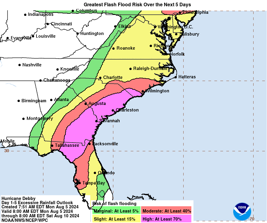
On this track, with the very slow movement, heavy rain will be a huge problem. The NHC is calling the rain amounts "potentially historic" and the flooding "likely catastrophic". Here is the rainfall totals from NOAA for the next five days. Areas of SE Georgia and eastern SC will have a terrible situation on their hands if these amounts verify from flash flooding and river flooding. If you do experience flooding in your area, please follow the rules of never driving through flooded roads. It happens so often that people try to drive through and end up needing rescued or worse.

A big question is how much wind will there be and how many power outages. No question there will be lots of power outages across SE Georgia and southern SC. For the Grand Strand and Pee Dee areas of SC we will have to see what the intensity of the storm is later in the week. My guess is that we'll see numerous power outages here as well. One of the more aggessive computer models for Debby restrenghening over the Atlantic is the usually reliable European model. I am including its prediction for maximum wind gusts. Keep in mind these are for 10 meters or 30 feet above the ground. For the Pee Dee and Grand Strand the worst of what we get will probably be Thursday into Friday.
Lastly, slow moving hurricanes and tropical storms are hard to predict and move erratically and sometimes stall completly. This is because the steering winds aloft are so weak. Because of that, be ready for changes and stay up to date with the very latest. As always, stay very aware of your own local forecast, follow the advice and direction of local Emergency Management, and stay safe!


Comments